Learn some Croatian before you visit Croatia! :-)
Our school offers online group & one-to-one lessons from qualified teachers – from €11/lesson!
Our school offers online group & one-to-one lessons from qualified teachers – from €11/lesson!
Croatians are immensely proud of their national parks, and with good reason. Although Croatia is a relatively small country, its national parks (nacionalni park) – which range from mountainous wildernesses, to island archipelagos to famous cascading waterfalls – cover more than 10% of the surface of the country.
While the focus of mainstream tourism falls squarely on Plitvička jezera, each of the other national parks has something unique to offer, and in contrast to Plitvice, which is famously busy year-round, the other parks typically provide plentiful opportunity to find calm and quiet and ... (with a bit of luck) escape from the range of your mobile phone operator.
There are 8 national parks spread across – primarily the western side of – Croatia:
Croatian also has 11 nature reserves (park prirode): Biokovo, Dinara, Kopački rit, Lonjsko polje, Medvednica, Papuk, Telašćica, Velebit, Vransko jezero, Učka, Žumberak – Samoborsko gorje and Lastovsko otočje.
You can find a map of Croatia's parks and reserves here, provided by the Croatian Parks Association (Parkovi Hrvatske).
A national park (nacionalni park) is a large, mostly unaltered area of extraordinary natural value which includes one or more ecosystems. A national park has a scientific, cultural, educational and recreational purpose. While activities that do not endanger the originality of nature are allowed, the economic use of natural resources is prohibited.
A nature reserve (park prirode) is defined as a natural (or partially cultivated) area of land/sea with ecological features of international or national importance, and which has aesthetic, ecological, educational, cultural-historical and tourist-recreational value. Within a nature reserve activities and actions are permitted that do not endanger its essential features and role.
 Roman Ruins in Brijuni National Park
The Brijuni Brijuni Islands (also known as the Brionian Islands from the Italian name Brioni) are an archipelago of fourteen small islands, located of the western Istrian coast, about 5km from the city of Pula. The islands are both a popular holiday destination and a national park.
The two largest islands are also the most well-known:
Brijuni was designated as a national park and memorial area on October 27, 1983.
The park covers 3635 hectares and include the islands Veliki Brijun, Mali Brijun, Sv. Marko, Gaz, Obljak, Supin, Supinic, Galija, Grunj, Vanga, Madona (Pusti), Vrsar, Jerolim, and Kotez are among the 14 islands that make up Istria's most indented and intriguing island group. They cover a total area of 734.6 hectares.
Most of the area of the national park belongs to the surrounding sea (2900 ha).
Following World War II Veliki Brijun became the summer residence of Yugoslav President Josip Broz Tito. He had his own zoo on the island, which is now a safari park, and one of the island’s main attractions. He also received visits from countless celebrities on Brijuni, such as Elizabeth Taylor, Richard Burton and Sophia Loren.
While the majority of the islands are off-limits to tourists, Veliki Brijun welcomes and caters to them. As with most of Croatia's national parks, visiting Brijuni itself is free, however since it's an island, you'll need help getting there!
Regular daytrip cruises from Pula give visitors a chance to spend a few hours on the island, it's also possible to stay overnight in the Hotel Neptun.
On the island there are bikes to rent – and bike paths to ride them on – as well as a safari park, there is also the chance to play golf, archery and tennis.
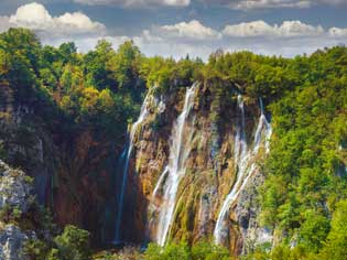
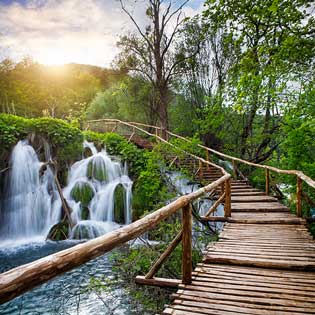
 Waterfall cascades in Plitvice Lakes National Park
The Plitvice Lakes (Plitvička jezera) are one of Croatia's oldest national parks, and certainly the most famous. It's also the most visited, and receives over a million visitors a year, keen to see – and walk among – the cascading waterfalls with their own eyes.
Plitvice is situated in eastern Lika, between the mountain ranges of Mala Kapela and Lika Pljeivica, and is accessible only by smaller, local roads. It's located in relative isolation about 10km from the Bosnian border and 50km from the nearest motorway (E71 Zagreb-Split).
The Plitvice Lakes are known for their unique colors, which range from azure to green and depend on the season, the weather and the amount of plantlife and minerals in the water at that moment.
Scientists have recorded over 1,200 different plant species within the national park, of which 75 are native. In addition, if you search hard enough, you can also find brown bears, wolves and eagles amongst the snakes, lizards and turtles.
The area around Plitvice makes great effort to preserve its historical customs and traditions:
Have you heard of Winnetou and Old Shatterhand? The filmmakers tasked with "recreating the Wild West" on location in Europe chose Plitvice and the surrounding area of Lika – with it's barren plateaus, rocky valleys and cascading waterfalls – to create the perfect setting for the filming of Karl May's Western novels in the 1960's.
On April 8, 1949, following the end of World War II, an area of 19,479 around the Plitvice Lakes was designated as Croatia's first national park, in recognition of its status as one of Europe's most spectacular natural wonders.
During the 1960s a modern road connection to the Plitvice Lakes was built, which resulted in increased traffic volumes. Several hotels and other structures were built during this time period based designs by various Croatian architects.
In 1979 the park was added to the UNESCO World Natural Heritage List for its "exceptional natural beauty".
Plitvice is a common daytrip destination from Zagreb or Zadar, and can easily be visited and experienced in a single day (read our assessment of whether Plitvice is really worth the visit).
We recommend you arrive as early as possible to be able to enjoy Plitvice in relative quiet and calm – in the afternoons the park is typically very busy. Alternatively it's worth considering staying a night to get a better feeling for the region, and then making an early start!
The quickest and easiest way to get to Plitvice is to take a tourist bus or private transfer from any nearby city. While the park is gorgeous all year, the ideal seasons to visit are spring and fall (note for summer tourists: swimming is not allowed in Plitvice Lakes). In the spring the falls are at their fullest as snow melts upstream, and in the fall the colours of leaves are spectacular.
 View toward the Adriatic from Kornati National Park
The Kornati National Park makes up a part of Croatia's largest island archipelago, which is located in northern Dalmatia midway between Zadar and Šibenik.
The Kornati archipelago consists of 140 islands, 89 of which form the Kornati National Park, which is administered by the nearby town of Murter, a town on the island of Murter that is connected to the mainland by a drawbridge at Tisno.
In Kornati, there are no towns or permanent settlements. Mainland landowners utilize simple cottages in well-protected coves like Vrulje, Kravjaica, Lavsa, and others as temporary shelters. The majority of the landowners come from Murter and Dugi Otok islands.
The largest of the islands is Kornat, which accounts for two-thirds of the national park's land area. Despite its length of 25.2 kilometers (15.7 miles), the island is only 2.5 kilometers wide (2 mi).
How on earth did the islands Babina Guzica and Kurba Vela, which in Croatian refer to buttocks and prostitution, get their names? When Austrian surveyors came to chart the archipelago at the end of the 19th century, local guides made fun of them by inventing rude names ... which have been the official names ever since!
In 1980 the southernmost 89 islands of the archipelago were named a national park, Nacionalni Park Kornati, to safeguard the islands and their marine environment. It is the Lower Kornati Islands (Donji Kornati), which contains the island of Kornat which is primarily covered by the National Park.
Kornati once had many vineyards, however a catastrophic disease of local grapevines forced residents to turn instead to olives groves. Today there are over 18,000 olive trees across the islands.
Daily boat trips to Kornati are organised from a variety of locations, including from Murter and Zadar, and this is the only way to visit the park (unless you have your own boat).
For those that would like to sail through the national park on your own, you'll need to buy a permit, the proceeds from which go toward the area's preservation, upkeep, and promotion.
If you like diving, don't forget to bring your snorkel and mask – Kornati has nine designated scuba diving locations which can be visited as part of an organised diving excursion.
 The beatiful coastline of Mljet National Park
Mljet is the 8th biggest island in Croatia – however the Mljet National Park comprises only one part of the island: the Great Lake (Veliko jezero) the Small Lake (Malo jezero), Soline Bay (zaljev Soline) and about 500 metres of sea around those parts.
In the Great Bay, you can find the island of St. Mary (Otok Svete Marije) as well as numerous fortifications and well-preserved tombs.
The biggest town is Babino Polje (Babino polje) which has a police station and a school, unlike the rest of the towns on the island.
On November 12, 1960, Mljet was designated as a national park. The park covers 3,100 hectares. It encompasses the northern portion of Mljet, one of the major south Dalmatian islands (10,000 ha).
The island has a long history of environmental damage:
The island of Mljet was first discovered by Greco-Roman geographers in the 6th century BC. Ancient Greeks referred to the island as Melita, which means honey (med). This name evolved over time to become the Slavic name Mljet.
You can walk or cycle along the beautiful, shaded footpaths around both lakes, which are well-marked paths throughout. If needs be, you can rent a bicycle in the nearby towns of Pomena, Polae, and Mali Most.
Swimming and sunbathing within the park is permitted, and recommended! The water is much warmer than on the island's seashores, which also makes it possible to swim later in the season. In our separate article on the island, you can find out what else there is to do in Mljet.
 A traditional hiking hut in Northern Velebit National Park
The rugged and rocky landscape of the Northern Velebit (Sjeverni Velebit) National Park is perfect for hiking. This is also the youngest national park in Croatia, established in 1999.
Northern Velebit is part of the Velebit mountain range, stretching along the inner side of the mountain range along the Kvarner Gulf for 150 kilometres. Its diversity of dense forests and pastures offers fantastic views for tourists and hikers, but it’s also an important habitat for brown bears, lynx and wolves.
The Croatian Mountain Rescue Service will gladly advise you on "surviving" your holiday in Croatia :-) Among other things, they emphatically recommend bringing and drinking plenty of water, not wearing flip-flops while climbing and not taking selfies. In case of emergency call 112!
In May 1999, Croatia's National Parliament passed a law proclaiming Northern Velebit Croatia's youngest national park. Thus the Sjeverni Velebit National Park was formed, within the boundaries of the Velebit Nature Reserve.
Numerous hiking and mountain trails run through the national park, leading to the peaks and through the valleys of Velebit - including some breathtaking views from the top.
Even though there are no designated cycling routes in Northern Velebit, there is a wide network of forest paths that can be used as cycling routes.
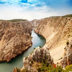
 The view into the canyon from Paklenica National Park
The Velebit mountain range contains not one, but two national parks! Paklenica National Park is located near Starigrad in northern Dalmatia, on the southern slopes of Velebit mountain, not far from Zadar.
Paklenica is the name of a river canyon at the centre of the park, and here you will find many native animal and plant species, and also enjoy one of many sports offerings including climbing, trekking, organized daytrips and many more.
On October 19, 1949, Paklenica was designated a national park. The park covers 3617 hectares.
In actual fact Paklenica, along with numerous other sites, was designated a national park as far back as 1928, but only by way of an ineffective law which had limited validity.
An artificial tunnel complex near the Velika Paklenica entrance was erected for Josip Broz Tito during the tensions between Yugoslavia and the Soviet Union in the late 1940s and early 1950s.
The only way to truly get to know Paklenica is to go hiking. There are 150–200 km of trails and paths in the Park area, ranging from those designed for tourists, to those designed for mountaineers, such as those leading to Velebit's highest peaks.
In fact, Paklenica National Park is Croatia's most popular climbing destination and Southeast Europe's largest. The nearby sea lends a distinct beauty to this climbing site, making Paklenica Riviera a great location for combining climbing with water activities.
 The Roški Slap within the Krka National Park
The Krka National Park is widely known for the magnificent waterfalls of the Krka river, and is located 15km from Šibenik in the Šibenik-Knin County.
The Krka river itself is 72km long, from its source at the foot of the Krčić waterfall until it flows into the Adriatic Sea. It has seven waterfalls and several active water mills in between.
The Roški slap is the most impressive waterfall, made of cascades that form the Visovačko jezero lake.
The National Park Krka is also home to five medieval fortresses, of which the fortress Ključica is the largest and best preserved.
In 1895 Šibenik became the first town in the world to have city-wide electricity thanks to Nikola Tesla and his inventions.
The region around what is now the national park has been under state protection since 1948.
On January 24, 1985, Krka National Park was officially made Croatia's seventh national park. The park covers 14,200 hectares, with 2,600 hectares of aquatic features.
Even though the most famous sights can be visited in a single day, a visit of several days should be considered for a comprehensive experience of Krka.
There are numerous well-marked walking and hiking trails that will take you to the most beautiful viewpoints and waterfalls.
Even though, unfortunately, you can't swim at the waterfalls in Krka national park, numerous excursion boats take you to the most important sights, such as the monastery island of Visovac.
 Hiking back down through Risnjak National Park
Risnjak National Park is one of the least known parks in Croatia, ranging from its lowest point at the source of the river Kupa (50m above sea level) to the peak of the Great Risnjak (Veliki Risnjak) mountain (1528m above sea level).
Although Risnjak is located in the most forested part of Croatia, Gorski Kotar, it is only 20 miles (32km) northeast of Rijeka and easily accessible by car via the town of Delnice. The main train line between Zagreb and Rijeka also passes through Delnice directly.
On September 15, 1953, Risnjak was designated a national park. Since then the size and border of the protected area has changed multiple times, but the massive Risnjak has always been included.
In 1997, the Croatian parliament voted to increase the park's area to its current size of 3,198 hectares, to include the Snjenik and Kupa river sources, as well as inhabited villages of Razloge, Razloki Okrug, and Kraevica villages.
Despite the abundance of natural treasures on offer, tourists are rarely to be found visiting Risnjak National Park. This means you'll have a large portion of the park to yourself to explore, and to enjoy the gorgeous and tranquil surroundings.
Risnjak is great for walking, skiing, fishing and a variety of other outdoors activities. The peak of Veliki Risnjak can be reached only on foot, starting from Crni Lug (3h) or on an unpaved road which begins in Gornje Jelenje (1h).
Although the vast majority of tourism in Croatia is concentrated on the Adriatic coast, Croatia has far more to offer the more curious visitor than just (admittedly spectacular) beaches, islands and azure ocean.
With an impressive – and incredibly diverse – 8 national parks and 11 nature reserves, we recommend you take the time to stray from the beaten path and plan to experience some of the amazing nature that Croatia has to offer. We're sure you won't regret it!
Before setting off to explore Croatia's national parks we suggest you ...
We’ll be happy to tell you more about our language school and the learning options we offer. Feel free to contact Andrea directly for a chat about any questions you might have!